Doyle Rice, USA TODAY
A hurricane warning for a part of Northern Florida remained in effect as federal officials warned that Tropical Storm Hermine would likely become a hurricane before making landfall on the state’s coast as early as late Thursday. Time
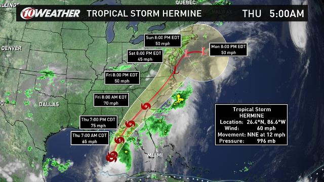
Tropical Storm Hermine strengthened Thursday morning as it barreled toward the Gulf Coast of Florida, where it’s expected to make landfall as a hurricane by early Friday.
It would be the state’s first hit from a hurricane since Wilma on Oct. 24, 2005, a record storm-free streak of 3,965 days.
In advance of the storm, Florida Gov. Rick Scott declared a state of emergency. A mandatory evacuation notice has been issued for Franklin County, located along the coast of the Gulf of Mexico on the Florida Panhandle. Several Florida schools announced closings on Thursday or Friday due to the storm.
As of 11 a.m., ET, Hermine was located 170 miles south-southwest of Appalachicola, Fla., with winds of 65 mph. It was moving to the north-northeast at 14 mph. A tropical storm becomes a hurricane when winds reach 74 mph. A hurricane warning is in effect for the Big Bend area of Florida’s Gulf Coast.
“Hurricane conditions are expected to reach the coast within the warning area beginning tonight,” the Hurricane Center said in its 11 a.m. advisory. “Winds are expected to first reach tropical storm strength by this afternoon, making outside preparations difficult or dangerous. Preparations to protect life and property should be rushed to completion.

Hermine is expected to make landfall just after midnight near Apalachicola.
The biggest concern is downed trees and widespread power outages caused by tropical-storm-force winds, according to the National Weather Service in Tallahassee.
Storm surge flooding in some areas along the Gulf Coast could reach up to 8 feet. There is a danger of life-threatening inundation within the next 36 hours, the hurricane center said.
Tornadoes could spin out of the system as it makes landfall, the weather service warned. Florida cities that will be at risk for tornadoes include Tampa, Orlando, Ocala, Melbourne, Gainesville, Jacksonville, Daytona Beach and Tallahassee, according to AccuWeather. The greatest threat for tornadoes is Thursday afternoon, the Storm Prediction Center forecast.
Areas on the western side of the storm could see between 10 and 15 inches of rain while east of it rainfall totals could reach 20 inches, potentially leading to flash flooding.
By Friday and Saturday, Hermine or its remnants will bring rain and wind to the Southeast and Mid-Atlantic coasts, though the exact track of the storm remains uncertain.
Tropical storm watches have been issued for Myrtle Beach, S.C., and for Wrightsville Beach and Surf City in North Carolina.
In the Pacific Ocean, Tropical Storm Madeline narrowly missed hitting the Big Island of Hawaii overnight, though Hurricane Lester could still impact the island chain over the weekend, according to the Central Pacific Hurricane Center.
Contributing: The Tallahassee Democrat


