
Tropical Storm Michael is born: Models see hurricane threat for North Florida | Analysis
Tallahassee Democrat
11:45 a.m. update
An intensifying storm system that became Tropical Storm Michael Sunday afternoon is setting its sights on the northern Gulf Coast, and forecasters say it will likely be a hurricane when it makes landfall.
“In fact, nearly every piece of intensity guidance brings the cyclone to hurricane strength before it reaches land, including the GFS, ECMWF, and UKMET global models, which all show significant deepening of the central pressure,” National Hurricance Center forecaster Robbie Berg wrote in a morning discussion of the storm.
Satellite data indicated the storm was packing 40 mph sustained winds at 1:30 p.m. with higher gusts. The National Hurricane Center said a reconnaissance flight was en route to the storm, which would provide forecasters with better data.
Gov. Rick Scott said he was planning on issuing a state of emergency declaration for North Florida and Big Bend counties in advance of what forecasters say will likely become Hurricane Michael.
The latest:
- Gov. Rick Scott: Tropical Storm Michael could be ‘similar to Hermine’
- Tropical Storm Michael: Tallahassee braces for potential hurricane impact
- Destructive Michael on track to bring Cat. 2 hurricane fury to North Florida | WeatherTiger
- Thousands of sandbags filled ahead of Hurricane Irma
- A Hurricane Michael preparation checklist from a storm-tested veteran in Tallahassee
Storm Tracker and Model Mixer: See the storm’s trajectory and latest computer runs
Make a plan: Your 2018 Leon County Disaster Survival Guide
Category 1 politics: Hurricane Hermine becomes a force in governor’s race as tropics churn
The region could see storm surge, rain and wind as early as late Tuesday, though forecasters noted the time frame of the storm is still in flux.
But forecasters noted there is an increasing risk of dangerous surge, rainfall and wind for those in the cone.
“We are alarmed, to put it mildly, by how it has established an intense core (with a large area of very high cloud tops, indicating strong convection) near the circulation center in the teeth of brisk westerly wind shear,” noted WeatherTiger forecaster Ryan Truchelut, who partners with the Tallahassee Democrat to provide hurricane forecasts. “Overnight modeling concurs that the upside risks of a stronger hurricane for FL Panhandle have risen.”
Forecast: A Hurricane Michael is a big possibility as storm system eyes Gulf | WeatherTiger
Storm Tracker and Model Mixer: See the storm’s trajectory and latest computer runs
Make a plan: Your 2018 Leon County Disaster Survival Guide
Category 1 politics:Hurricane Hermine becomes a force in governor’s race as tropics churn
The models for Michael
Tallahassee Democrat president and weather watcher Skip Foster, who posts winter and tropical weather forecasts on Facebook, wrote the following earlier this morning.
Very serious situation developing.
I’m quite concerned about the potential impact of what will likely be Hurricane Michael for the following reasons:
- There will be very little lead time for this storm. Normally we are tracking storms for days through the Caribbean or Atlantic. With Michael, somebody is going to wake up Monday morning under a hurricane watch that had no idea there was a threat.
- Most models are showing very rapid strengthening of the storm. To wit, the 0z Euro shows Michael bombing out at 945 mb of pressure — almost as low as Florence was (939 mb) at its strongest. Florence was a Category 4 storm.
- Because Michael is a late bloomer, the models are having a hard time settling on a track which means a large area of the Gulf coast is under the gun. 0z models ranged from a Mobile Bay landfall all the way over to the Taylor County FL coast.
- Timing is also up in the air. Model landfalls are as early as late Wednesday morning (GFS) and as late as late Thursday night (Canadian).
A quick model-by-model breakdown:
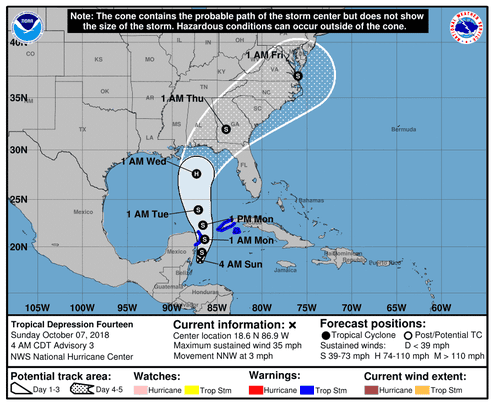 The official forecast track for the tropical depression forecasters say will become Hurricane Michael. (Photo: National Hurricane Center)
EURO — very disconcerting for TLH. Makes landfall at Mexico Beach as at least a Cat 3. The problem is, the storm has really turned NE by then so it ends up passing over Gretna/Greensboro, bringing powerful hurricane force wind gusts to much of the TLH metro area, esp to the west.
GFS — Walton County (30-A) landfall. Not quite as strong as Euro and less of a NE component so the storm moves up to around Dothan and TLH has a breezy day.
UK — landfall on Taylor County coast with a move toward Perry then around Lake City.
Canadian — here’s one for TLHers to root for — shows a much slower storm making landfall Thursday night at Mobile Bay.
Bottom line
Still early. Intensity forecasts could easily be overdone. Track forecast could still fluctuate widely. This is a situation where a lot of folks from Mobile to Cross City will end up just having a breezy couple days midweek. But if you draw the short straw on Michael, it could be ugly and you won’t have much time to prepare. Watch this one like a hawk.
Skip Foster is president of the Tallahassee Democrat and a vigilant weather watcher with his own weather station.
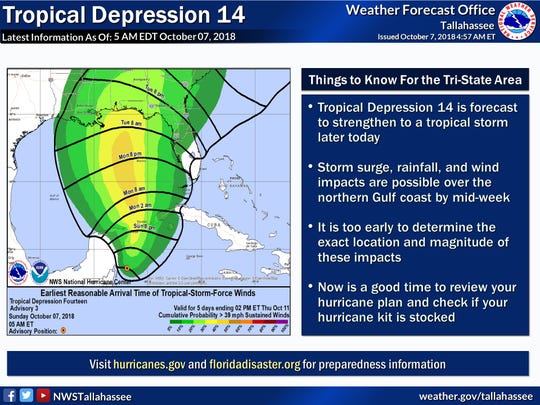 The wind time tracker graphic for the tropical depression forecasters say will become Hurricane Michael.